AMI-16149
+351 961 266 322 / 964148343 |
Rua do Luar
8500-510 Portimão
Home
For Sale
For Rent
Favorites (
0
)
Seeking property
Sell property
Contacts
Search
Search Property:
REF / Properties / Zone
Business type
Sale
Long Term Rental
Leasehold
Time Sharing
Transfer Position
Property type...
Apartment
House/Villa
Land
Farm
Commercial
Office
Shop
Warehouse
Garage
Building
Rest/Coffee-Shop
Hotel
Bedroom
Storage room
Other
Location...
[1] Marbella
[7] Zahora
{ > Barbate} [10]
{ > Marbella} [1]
{Cádiz} [10]
{Faro} [136]
{Faro > Albufeira} [3]
{Faro > Faro} [1]
{Faro > Lagoa (Algarve)} [26]
[7] Ferragudo
[1] Porches
{Faro > Lagos} [18]
{Faro > Loulé} [1]
{Faro > Monchique} [2]
{Faro > Olhão} [2]
{Faro > Portimão} [57]
[9] Alvor
[48] Portimão
{Faro > Silves} [15]
[1] Armação de Pêra
[11] Silves
[2] São Marcos da Serra
{Faro > Tavira} [1]
{Faro > Vila do Bispo} [10]
{Leiria} [1]
{Lisboa} [1]
{Málaga} [1]
{Porto} [1]
{Setúbal} [1]
From
To
Typology
T0
T0+1
T1
T1+1
T2
T2+1
T3
T3+1
T4
T4+1
T5
T6
T7
T8
T9
>T9
Typology
T0
T0+1
T1
T1+1
T2
T2+1
T3
T3+1
T4
T4+1
T5
T6
T7
T8
T9
>T9
Price
25.000€
50.000€
75.000€
100.000€
125.000€
150.000€
175.000€
200.000€
250.000€
300.000€
350.000€
400.000€
500.000€
750.000€
1.000.000€
2.000.000€
5.000.000€
10.000.000€
Price
25.000€
50.000€
75.000€
100.000€
125.000€
150.000€
175.000€
200.000€
250.000€
300.000€
350.000€
400.000€
500.000€
750.000€
1.000.000€
2.000.000€
5.000.000€
10.000.000€
only Reduced price
only Luxury
only bank properties
only exchanges
Featured
5 bedroom Villa
Almada
725.000
€
3 bedroom Apartment
Torraltinha
Lagos
780.000
€
Exchange Rates
EUR
> 0.873 GBP
GBP
> 1.145 EUR
EUR
> 1.166 USD
USD
> 0.858 EUR
< Prev
1
2
3
4
Next >
33 prop.
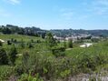
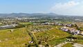
Plot of land Agricultural with 151950sqm Alcobaça
€ 7.250.000
0
REF
AV-PBI-1253
151.950m²
Sale
Important allotment with Alcobaça whose urbanization works were approved by the CMA, for housing (single-family and multi-family), commerce and services, with a total Gross Construction Area (ABC) of 151,950sqm. Energy Class: Exempt The current city of Alcobaça has grown in the valleys of the Alcoa River and the Baça River. The area of the current municipality of Alcobaça was inhabited by the Romans, but the denomination was left to it by the Arabs, whose occupation denotes an era of progress judging by the numerous toponyms of the adjacent lands that remind them, such as Alcobaça, Alfeizerão, Aljubarrota, Alpedriz and other toponyms. When Alcobaça was reconquered, the locality had access to the nearby sea that formed the great Pederneira Lagoon that reached Cós and allowed them to sail the vessels that transported to the rest of the country the delicious fruits produced in the region thanks to the technique introduced by the monks of Cisterer. Afonso Henriques sweetened the Lands of Alcobaça to the Cistercian monks on April 8,1153, with the obligation to burp them; the donations made over the various reigns came to constitute a vast territory - The Coutos of Alcobaça - ranging from about São Pedro de Moel to São Martinho do Porto and from Aljubarrota to Alvorninha, and the territory reached its maximum in the reign of D. Fernando I. The monks of Cistermen came to be lords of 14 villages of which 4 were sea ports: Alfeizerão, São Martinho do Porto, Pederneira and Paredes da Vitória. The monks of Alcobaça, in addition to their religious and cultural activity- have had public classes since 1269 and in them, in addition to Humanities, Logic and Theology, taught agricultural techniques - developed a remarkable and lasting colonizing action, putting into practice the agricultural innovations experienced in other monasteries and thanks to which they burped the lands, dried sticks, introduced cultures suitable to each land and organized farms or farms, what they called farms, creating practically from nothing an agricultural region that has remained to this day as one of the most productive in Portugal. Joaquim Vieira Naatividade refers to the monks of Alcobaça, as the monks-agronomes. The municipalities of Alcobaça and Nazaré, as well as part of the northern municipality of Caldas da Rainha, was burped and administered by the Alcobacense monks. This vast territory was called the Coutos de Alcobaça.
Schedule a Visit
More information
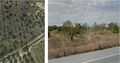
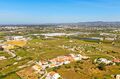
Land Agricultural with 218000sqm Tavira
€ 9.900.000
0
REF
AV-PBI-CG1264
218.000m²
Sale
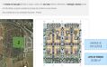
Land in Tavira with 21.8 hectares, in the connection between the A22 and the city center of Tavira, in a place with excellent development potential. The land is located in the vicinity of the city of Tavira, in the Western Algarve, 37 km from Faro (39 km from the airport), 300 km from Lisbon and 172 km from Seville. The Pêro Gil Detail Plan, where the land is integrated, allows to develop a project with a total construction potential of 76,021sqm for residential space, a hotel, commercial space. The area is divided into three execution units and a rustic area, facilitating the proper phase of the project: Execution Unit 1 divides the space into nine lots, with one for hotel unit, five for collective housing (two of them with trade) and three lots for equipment (one of them, for private clinic). Part of the adjacent land will be kept rustic (79,885sqm), with agricultural potential. Execution Unit 2 divides the urban space into eight distinct lots for collective housing (where, in three of these, trade areas are expected to exist on the ground floor). This unit has a Nascent - West orientation. Execution Unit 3 is structured in twenty-seven separate lots, of which three are intended for collective housing and the remaining twenty-four for detached dwellings. In the northern part of the EU3, next to the EU2, the retention basin provided for in the Pêro Gil Detail Plan is inserted. In addition to the three Execution Units, which make up the Urban Area, there is a Rustic Area that will be maintained, conducive to agricultural culture, a total of 79,885sqm. The predominant crops in this region are of a wine and fruit nature. The Total Land Area amounts to 218,837sqm, corresponding to an Urban Area of 138,952sqm and a Rustic Area of 79,885sqm. The surroundings are characterized by the existence of land, mixed buildings and scattered villas.
Schedule a Visit
More information
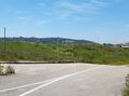
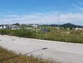
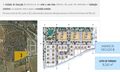
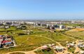
Land with 31120sqm Lejana Faro
€ 10.000.000
0
REF
AV-PBI-1312
31.120m²
Sale
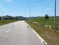
Land in Faro in an urban area for allotment of 157 dwellings of which Housing and commercial with 31.120sqm. In this subdivision it will be possible to implant swimming pools and leisure areas that will be of a private nature for the lots to which they relate. It will also be possible to build a Children's Garden and a Multipurpose Sport. 5min from the airport and the center of Faro, located near the latest housing complex of Faro. Road accesses are tarred and close to the junctions to the A22, IC4 and N2, with access to supermarkets, shopping centre and others. We have the opportunity for an innovative and efficient, energy-sustainable project to improve the quality of life in the residential market.
Schedule a Visit
More information
< Prev
1
2
3
4
Next >
33 prop.
 AMI-16149AMI-16149
 0
0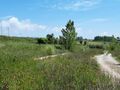
 REF AV-PBI-1253151.950m²Sale
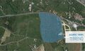 0
0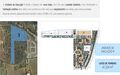
 REF AV-PBI-CG1264218.000m²Sale
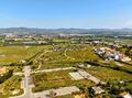 0
0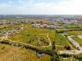

 REF AV-PBI-131231.120m²
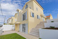 5 bedroom Villa
 3 bedroom Apartment