
 3 bedroom Apartment
1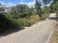
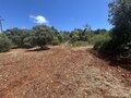
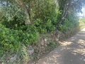
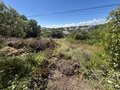
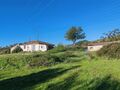
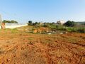
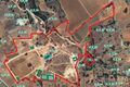
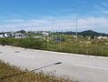
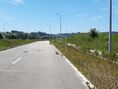
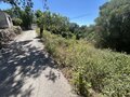 REF AV-PBI-139814.212m²
We present a truly exclusive opportunity in the heart of the Algarve: a magnificent plot of land located in the prestigious parish of São Clemente, in Loulé, where the tranquility of nature blends seamlessly with the sophistication of a contemporary luxury project. With a generous total area of 14,212 sqm, this property offers privacy, space, and a rare natural setting, ideal for those looking to create a unique residence in one of the most desirable destinations in southern Portugal. The land benefits from an approved PIP for the construction of a sophisticated luxury villa, designed to provide comfort, exclusivity, and perfect integration with the surrounding landscape. The project includes 377 sqm of gross construction area, distributed across a basement, ground floor, and first floor, as well as an elegant private swimming pool and spacious outdoor leisure areas. The future villa may enjoy open views over the Algarve countryside, excellent sun exposure, and a peaceful environment, while remaining close to the center of Loulé, the golden beaches of the Algarve, renowned golf courses, and all essential amenities. A rare property, perfect as a permanent residence, exclusive holiday home, or premium investment, where luxury, nature, and location come together in perfect harmony.
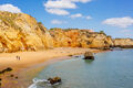
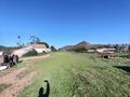
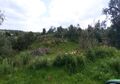
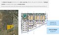
Plot of land with 1764sqm Canavial São Gonçalo de Lagos
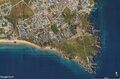 1
1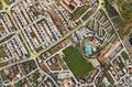
 REF AV-PBI-1382-L331.764m²Sale
A Luxury Seaside Getaway! Imagine a private oasis, carved into 1193sqm of pure exuberance, where wild nature meets absolute refinement. This exceptional plot, nestled in the prestigious Cascade Resort, in Lagos, Porto de Mós, invites you to build the villa of your dreams. With a generous construction area of 200sqm, you will have the freedom to create a space that reflects your lifestyle and your most intimate desires. A Paradise at Your Doorstep: Privileged location: Situated just a few steps from the stunning Porto de Mós beach, this plot offers the best of both worlds: the tranquility of nature and the convenience of being close to everything you need. Stunning Landscapes: Wake up to panoramic views of the Atlantic Ocean and lush surrounding vegetation. Every day, a new picture emerges before your eyes. Privacy and exclusivity: Enjoy moments of pure relaxation in a peaceful and safe environment, surrounded by nature and natural beauty. Unlimited potential: With 200sqm of built area, the possibilities are endless. Design a modern, minimalist home with wide open spaces and balconies that stretch to the horizon. Or, if you prefer, opt for a more traditional style, with architectural details that evoke the beauty of the region. Live the Life You Always Dreamed of: This lot is much more than just a piece of land. It's a unique opportunity to build a personalized retreat where you can create unforgettable memories with family and friends. Imagine relaxing afternoons, romantic al fresco dinners, or simply contemplating the beauty of nature. Don't miss this chance to acquire a piece of paradise. Contact us and schedule a visit to see this incredible lot and start building the home of your dreams. A safe investment for the future: In addition to being a perfect place to live, this lot also represents a safe and promising investment. The Lagos de Porto de Mós region is constantly developing, with a growing demand for luxury properties. Lot Characteristics: Total area: 1193sqm Construction area: 200sqm Location: Cascade Resort, Lagoa de Porto de Mós Proximity to the beach: Just a few steps from Porto de Mós beach Panoramic views: Atlantic Ocean and lush nature Unlimited potential for customization Contact us and find out more about this incredible lot.
€ 700.000
1REF AV-PBI-1382-L331.764m²SaleA Luxury Seaside Getaway! Imagine a private oasis, carved into 1193sqm of pure exuberance, where wild nature meets absolute refinement. This exceptional plot, nestled in the prestigious Cascade Resort, in Lagos, Porto de Mós, invites you to build the villa of your dreams. With a generous construction area of 200sqm, you will have the freedom to create a space that reflects your lifestyle and your most intimate desires. A Paradise at Your Doorstep: Privileged location: Situated just a few steps from the stunning Porto de Mós beach, this plot offers the best of both worlds: the tranquility of nature and the convenience of being close to everything you need. Stunning Landscapes: Wake up to panoramic views of the Atlantic Ocean and lush surrounding vegetation. Every day, a new picture emerges before your eyes. Privacy and exclusivity: Enjoy moments of pure relaxation in a peaceful and safe environment, surrounded by nature and natural beauty. Unlimited potential: With 200sqm of built area, the possibilities are endless. Design a modern, minimalist home with wide open spaces and balconies that stretch to the horizon. Or, if you prefer, opt for a more traditional style, with architectural details that evoke the beauty of the region. Live the Life You Always Dreamed of: This lot is much more than just a piece of land. It's a unique opportunity to build a personalized retreat where you can create unforgettable memories with family and friends. Imagine relaxing afternoons, romantic al fresco dinners, or simply contemplating the beauty of nature. Don't miss this chance to acquire a piece of paradise. Contact us and schedule a visit to see this incredible lot and start building the home of your dreams. A safe investment for the future: In addition to being a perfect place to live, this lot also represents a safe and promising investment. The Lagos de Porto de Mós region is constantly developing, with a growing demand for luxury properties. Lot Characteristics: Total area: 1193sqm Construction area: 200sqm Location: Cascade Resort, Lagoa de Porto de Mós Proximity to the beach: Just a few steps from Porto de Mós beach Panoramic views: Atlantic Ocean and lush nature Unlimited potential for customization Contact us and find out more about this incredible lot.
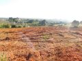
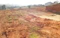
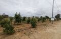
Land Urban with 290000sqm Portimão - water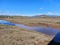 0
0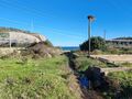
 REF AV-PBI-1351290.000m²Sale
This vast plot of land, with a total area of 290000sqm, has exceptional development potential, ideal for mixed-use, industrial or urban projects. The property, divided into four rural areas, includes over 2,000sqm of existing buildings, including rural buildings and infrastructures to be restored, totalling 2,127sqm of registered area. Its privileged location, next to an urban centre and with two access points via public roads, guarantees easy access and convenience, and is partially covered by a Detailed Plan. The estate, which once operated as an aquaculture export farm, is a true oasis of natural resources, with an abundance of water from various sources, a lagoon and the Boina stream, which offers direct access to the Arade River and the sea, a rare and valuable asset. The availability of water, the existing sewage network and other public networks facilitate any type of development. The flat terrain of the land and the various access points available make getting around the property extremely easy. Located next to the largest developments in Portimão, Morgado do Reguendo and Morgado do Arge, this estate represents an unmissable investment opportunity for those looking to develop innovative and sustainable projects. Please contact us for more details.
€ 890.000
0REF AV-PBI-1351290.000m²SaleThis vast plot of land, with a total area of 290000sqm, has exceptional development potential, ideal for mixed-use, industrial or urban projects. The property, divided into four rural areas, includes over 2,000sqm of existing buildings, including rural buildings and infrastructures to be restored, totalling 2,127sqm of registered area. Its privileged location, next to an urban centre and with two access points via public roads, guarantees easy access and convenience, and is partially covered by a Detailed Plan. The estate, which once operated as an aquaculture export farm, is a true oasis of natural resources, with an abundance of water from various sources, a lagoon and the Boina stream, which offers direct access to the Arade River and the sea, a rare and valuable asset. The availability of water, the existing sewage network and other public networks facilitate any type of development. The flat terrain of the land and the various access points available make getting around the property extremely easy. Located next to the largest developments in Portimão, Morgado do Reguendo and Morgado do Arge, this estate represents an unmissable investment opportunity for those looking to develop innovative and sustainable projects. Please contact us for more details.
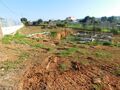
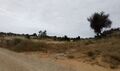
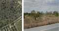
Land Agricultural with 14320sqm Olhão - water hole, water, arable crop, olive trees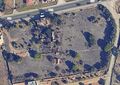 0REF AV-PBI-136114.320m²Sale
We have a remarkable investment opportunity in Marim, Quelfes, Olhão. This mixed plot, with approximately 1.5 hectares, is strategically located next to the EN125. Of this total area, 1800sqm is urban, which opens up a wide range of possibilities for construction and development. On the site, there are ruined buildings awaiting renovation or the conception of new, tailor-made projects. One of the great benefits is the existence of a water borehole, guaranteeing a constant and essential supply for any purpose. For those who enjoy nature and agriculture, this property is a real treasure. It has a vast arable crop, including olive trees, carob trees, a citrus orchard and almond trees, all thriving in the fertile underlying soil. This is the ideal location for those who dream of developing a housing or tourism project in the urban area, investing in agriculture with established crops and access to water, or even combining the best of both worlds by creating a mixed property with a residence and agricultural production. It's a unique chance to acquire a property with so much potential in a strategic location in the Algarve. Contact us for more information.
€ 900.000
0REF AV-PBI-136114.320m²SaleWe have a remarkable investment opportunity in Marim, Quelfes, Olhão. This mixed plot, with approximately 1.5 hectares, is strategically located next to the EN125. Of this total area, 1800sqm is urban, which opens up a wide range of possibilities for construction and development. On the site, there are ruined buildings awaiting renovation or the conception of new, tailor-made projects. One of the great benefits is the existence of a water borehole, guaranteeing a constant and essential supply for any purpose. For those who enjoy nature and agriculture, this property is a real treasure. It has a vast arable crop, including olive trees, carob trees, a citrus orchard and almond trees, all thriving in the fertile underlying soil. This is the ideal location for those who dream of developing a housing or tourism project in the urban area, investing in agriculture with established crops and access to water, or even combining the best of both worlds by creating a mixed property with a residence and agricultural production. It's a unique chance to acquire a property with so much potential in a strategic location in the Algarve. Contact us for more information.
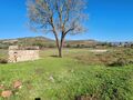
Land Urban with 720sqm Ferragudo Lagoa (Algarve) - excellent access 0REF AV-PBI-751720m²Sale
Land with APPROVED PROJECT for a HOSTEL with 20 rooms, Lounge, Laundry, Parking in the Basement. This project is located in an area of excellence 200 meters from the small village of Ferragudo, the land and project is facing south with an excellent solar exposure, has excellent access, this project is located in a surrounding area where it is part of a project requalification of the entire pedestrian zone of Ferragudoo by Camarã Municipal de Lagoa. What makes this project even more attractive. Excellent Investment.
€ 950.000
0REF AV-PBI-751720m²SaleLand with APPROVED PROJECT for a HOSTEL with 20 rooms, Lounge, Laundry, Parking in the Basement. This project is located in an area of excellence 200 meters from the small village of Ferragudo, the land and project is facing south with an excellent solar exposure, has excellent access, this project is located in a surrounding area where it is part of a project requalification of the entire pedestrian zone of Ferragudoo by Camarã Municipal de Lagoa. What makes this project even more attractive. Excellent Investment.
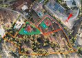
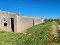
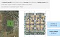
Land Urban with approved project Estombâr Lagoa (Algarve) - garage, excellent access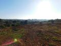 1
1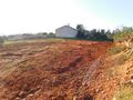
 REF AV-PBI-7494.690m²
Land with a total area of 4690sqm, with PROJECT APPROVED AND WITH LICENSE FOR CONSTRUCTION of 15 townhouses, reception, pool, bar, laundry, living room, garage, green areas. This project is located in an area of Excellence 1.5 km from the small Villa de Ferragudo, also very close to a new project of Luxury with Villas, Apartments and Golf Resort, the land and project is facing south with an excellent solar exposure, has excellent access, this project is located in a new surrounding area and where it is inserted in a project of requalification of the entire pedestrian zone of Ferragudoo by Camarã Municipal de Lagoa. What makes this project even more attractive. Excellent Investment.
€ 1.450.000
1REF AV-PBI-7494.690m²Land with a total area of 4690sqm, with PROJECT APPROVED AND WITH LICENSE FOR CONSTRUCTION of 15 townhouses, reception, pool, bar, laundry, living room, garage, green areas. This project is located in an area of Excellence 1.5 km from the small Villa de Ferragudo, also very close to a new project of Luxury with Villas, Apartments and Golf Resort, the land and project is facing south with an excellent solar exposure, has excellent access, this project is located in a new surrounding area and where it is inserted in a project of requalification of the entire pedestrian zone of Ferragudoo by Camarã Municipal de Lagoa. What makes this project even more attractive. Excellent Investment.
Land Rustic flat Ajuda Lisboa - construction viability, excellent access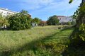 0
0
 REF AV-PBI-13882.000m²Sale
We present an excellent investment opportunity in a plot of land with a total area of 2,000sqm, currently rustic but with the feasibility of conversion into urban land. With a strategic configuration of approximately 22 meters in depth and 55 meters of usable width, the asset benefits from a privileged location, situated between the Ajuda University Campus currently in full expansion, the Liga Foundation, the Ajuda Humanitarian Firefighters Association, and the vast green area of Monsanto Forest Park. A short distance away, the historical imposing presence of the Ajuda National Palace stands out. According to the Lisbon Municipal Master Plan Regulations, namely articles 49,53,54, and 55, the feasibility of constructing a residential building with five floors is projected. This building perspective provides for a front of about 50 meters and a depth of 15 meters, with the remainder of the plot designated as a patio. In accordance with paragraph c) of point 2 of article 54 of the PDM, which establishes a maximum Gross Utilization Index (IUB) of 2sqm/sqm, the residential occupation could reach approximately 4,000sqm. The Ajuda area in Lisbon is one of the areas with the greatest potential for appreciation in the capital, managing to combine the tradition of a historic neighborhood with the modernity brought by the expansion of its university campus. Located on a slope offering clear views and proximity to the Tagus River, the parish benefits from a unique environment that combines the tranquility of Monsanto Forest Park with the cultural heritage of monuments such as the Ajuda Palace. It is a strategic location for those looking for a balanced lifestyle, with excellent access to Belém and the city center, attracting more and more young professionals and families. We invite you to request a detailed evaluation of this property to explore its full construction and investment potential. For more information, please contact us.
€ 2.900.000
0REF AV-PBI-13882.000m²SaleWe present an excellent investment opportunity in a plot of land with a total area of 2,000sqm, currently rustic but with the feasibility of conversion into urban land. With a strategic configuration of approximately 22 meters in depth and 55 meters of usable width, the asset benefits from a privileged location, situated between the Ajuda University Campus currently in full expansion, the Liga Foundation, the Ajuda Humanitarian Firefighters Association, and the vast green area of Monsanto Forest Park. A short distance away, the historical imposing presence of the Ajuda National Palace stands out. According to the Lisbon Municipal Master Plan Regulations, namely articles 49,53,54, and 55, the feasibility of constructing a residential building with five floors is projected. This building perspective provides for a front of about 50 meters and a depth of 15 meters, with the remainder of the plot designated as a patio. In accordance with paragraph c) of point 2 of article 54 of the PDM, which establishes a maximum Gross Utilization Index (IUB) of 2sqm/sqm, the residential occupation could reach approximately 4,000sqm. The Ajuda area in Lisbon is one of the areas with the greatest potential for appreciation in the capital, managing to combine the tradition of a historic neighborhood with the modernity brought by the expansion of its university campus. Located on a slope offering clear views and proximity to the Tagus River, the parish benefits from a unique environment that combines the tranquility of Monsanto Forest Park with the cultural heritage of monuments such as the Ajuda Palace. It is a strategic location for those looking for a balanced lifestyle, with excellent access to Belém and the city center, attracting more and more young professionals and families. We invite you to request a detailed evaluation of this property to explore its full construction and investment potential. For more information, please contact us.
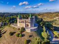
Land with approved project Guia Albufeira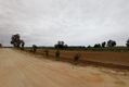 0
0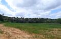
 REF AV-PBI-1190100.000m²Sale
Magnificent land with approved project for construction of 4-star rural farm. It has a useful interior floor area of 1606.7sqm. It is located in the municipality of Albufeira, in the parish of Guia at an altitude of 50m, distancing itself from the sea of less than 5.0 km (IV3). Project: The building consists of a single block with two floors. The floor 0, at the level of the sandstone quota on one of the facades, will consist of a parking space, technical areas and double rooms with its own sanitary installation. The upper floor will consist of double rooms also with its own sanitary installation and in the central area the reception area, in addition to two dining/living rooms supported by a kitchen and its support areas. The planned air conditioning is vrv type. For ventilation, four air treatment units are planned to be installed, one of them with heat recovery. For the production of AQS, a heat pump system will be installed. Elevators are also planned. Great business investment for rural tourism in the Algarve.
€ 3.500.000
0REF AV-PBI-1190100.000m²SaleMagnificent land with approved project for construction of 4-star rural farm. It has a useful interior floor area of 1606.7sqm. It is located in the municipality of Albufeira, in the parish of Guia at an altitude of 50m, distancing itself from the sea of less than 5.0 km (IV3). Project: The building consists of a single block with two floors. The floor 0, at the level of the sandstone quota on one of the facades, will consist of a parking space, technical areas and double rooms with its own sanitary installation. The upper floor will consist of double rooms also with its own sanitary installation and in the central area the reception area, in addition to two dining/living rooms supported by a kitchen and its support areas. The planned air conditioning is vrv type. For ventilation, four air treatment units are planned to be installed, one of them with heat recovery. For the production of AQS, a heat pump system will be installed. Elevators are also planned. Great business investment for rural tourism in the Algarve.
Plot of land Agricultural with 151950sqm Alcobaça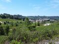 0
0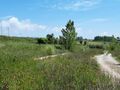
 REF AV-PBI-1253151.950m²Sale
Important allotment with Alcobaça whose urbanization works were approved by the CMA, for housing (single-family and multi-family), commerce and services, with a total Gross Construction Area (ABC) of 151,950sqm. Energy Class: Exempt The current city of Alcobaça has grown in the valleys of the Alcoa River and the Baça River. The area of the current municipality of Alcobaça was inhabited by the Romans, but the denomination was left to it by the Arabs, whose occupation denotes an era of progress judging by the numerous toponyms of the adjacent lands that remind them, such as Alcobaça, Alfeizerão, Aljubarrota, Alpedriz and other toponyms. When Alcobaça was reconquered, the locality had access to the nearby sea that formed the great Pederneira Lagoon that reached Cós and allowed them to sail the vessels that transported to the rest of the country the delicious fruits produced in the region thanks to the technique introduced by the monks of Cisterer. Afonso Henriques sweetened the Lands of Alcobaça to the Cistercian monks on April 8,1153, with the obligation to burp them; the donations made over the various reigns came to constitute a vast territory - The Coutos of Alcobaça - ranging from about São Pedro de Moel to São Martinho do Porto and from Aljubarrota to Alvorninha, and the territory reached its maximum in the reign of D. Fernando I. The monks of Cistermen came to be lords of 14 villages of which 4 were sea ports: Alfeizerão, São Martinho do Porto, Pederneira and Paredes da Vitória. The monks of Alcobaça, in addition to their religious and cultural activity- have had public classes since 1269 and in them, in addition to Humanities, Logic and Theology, taught agricultural techniques - developed a remarkable and lasting colonizing action, putting into practice the agricultural innovations experienced in other monasteries and thanks to which they burped the lands, dried sticks, introduced cultures suitable to each land and organized farms or farms, what they called farms, creating practically from nothing an agricultural region that has remained to this day as one of the most productive in Portugal. Joaquim Vieira Naatividade refers to the monks of Alcobaça, as the monks-agronomes. The municipalities of Alcobaça and Nazaré, as well as part of the northern municipality of Caldas da Rainha, was burped and administered by the Alcobacense monks. This vast territory was called the Coutos de Alcobaça.
€ 7.250.000
0REF AV-PBI-1253151.950m²SaleImportant allotment with Alcobaça whose urbanization works were approved by the CMA, for housing (single-family and multi-family), commerce and services, with a total Gross Construction Area (ABC) of 151,950sqm. Energy Class: Exempt The current city of Alcobaça has grown in the valleys of the Alcoa River and the Baça River. The area of the current municipality of Alcobaça was inhabited by the Romans, but the denomination was left to it by the Arabs, whose occupation denotes an era of progress judging by the numerous toponyms of the adjacent lands that remind them, such as Alcobaça, Alfeizerão, Aljubarrota, Alpedriz and other toponyms. When Alcobaça was reconquered, the locality had access to the nearby sea that formed the great Pederneira Lagoon that reached Cós and allowed them to sail the vessels that transported to the rest of the country the delicious fruits produced in the region thanks to the technique introduced by the monks of Cisterer. Afonso Henriques sweetened the Lands of Alcobaça to the Cistercian monks on April 8,1153, with the obligation to burp them; the donations made over the various reigns came to constitute a vast territory - The Coutos of Alcobaça - ranging from about São Pedro de Moel to São Martinho do Porto and from Aljubarrota to Alvorninha, and the territory reached its maximum in the reign of D. Fernando I. The monks of Cistermen came to be lords of 14 villages of which 4 were sea ports: Alfeizerão, São Martinho do Porto, Pederneira and Paredes da Vitória. The monks of Alcobaça, in addition to their religious and cultural activity- have had public classes since 1269 and in them, in addition to Humanities, Logic and Theology, taught agricultural techniques - developed a remarkable and lasting colonizing action, putting into practice the agricultural innovations experienced in other monasteries and thanks to which they burped the lands, dried sticks, introduced cultures suitable to each land and organized farms or farms, what they called farms, creating practically from nothing an agricultural region that has remained to this day as one of the most productive in Portugal. Joaquim Vieira Naatividade refers to the monks of Alcobaça, as the monks-agronomes. The municipalities of Alcobaça and Nazaré, as well as part of the northern municipality of Caldas da Rainha, was burped and administered by the Alcobacense monks. This vast territory was called the Coutos de Alcobaça.
Land Agricultural with 218000sqm Tavira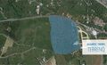 0
0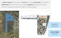
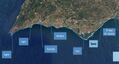 REF AV-PBI-CG1264218.000m²Sale
Land in Tavira with 21.8 hectares, in the connection between the A22 and the city center of Tavira, in a place with excellent development potential. The land is located in the vicinity of the city of Tavira, in the Western Algarve, 37 km from Faro (39 km from the airport), 300 km from Lisbon and 172 km from Seville. The Pêro Gil Detail Plan, where the land is integrated, allows to develop a project with a total construction potential of 76,021sqm for residential space, a hotel, commercial space. The area is divided into three execution units and a rustic area, facilitating the proper phase of the project: Execution Unit 1 divides the space into nine lots, with one for hotel unit, five for collective housing (two of them with trade) and three lots for equipment (one of them, for private clinic). Part of the adjacent land will be kept rustic (79,885sqm), with agricultural potential. Execution Unit 2 divides the urban space into eight distinct lots for collective housing (where, in three of these, trade areas are expected to exist on the ground floor). This unit has a Nascent - West orientation. Execution Unit 3 is structured in twenty-seven separate lots, of which three are intended for collective housing and the remaining twenty-four for detached dwellings. In the northern part of the EU3, next to the EU2, the retention basin provided for in the Pêro Gil Detail Plan is inserted. In addition to the three Execution Units, which make up the Urban Area, there is a Rustic Area that will be maintained, conducive to agricultural culture, a total of 79,885sqm. The predominant crops in this region are of a wine and fruit nature. The Total Land Area amounts to 218,837sqm, corresponding to an Urban Area of 138,952sqm and a Rustic Area of 79,885sqm. The surroundings are characterized by the existence of land, mixed buildings and scattered villas.
€ 9.900.000
0REF AV-PBI-CG1264218.000m²SaleLand in Tavira with 21.8 hectares, in the connection between the A22 and the city center of Tavira, in a place with excellent development potential. The land is located in the vicinity of the city of Tavira, in the Western Algarve, 37 km from Faro (39 km from the airport), 300 km from Lisbon and 172 km from Seville. The Pêro Gil Detail Plan, where the land is integrated, allows to develop a project with a total construction potential of 76,021sqm for residential space, a hotel, commercial space. The area is divided into three execution units and a rustic area, facilitating the proper phase of the project: Execution Unit 1 divides the space into nine lots, with one for hotel unit, five for collective housing (two of them with trade) and three lots for equipment (one of them, for private clinic). Part of the adjacent land will be kept rustic (79,885sqm), with agricultural potential. Execution Unit 2 divides the urban space into eight distinct lots for collective housing (where, in three of these, trade areas are expected to exist on the ground floor). This unit has a Nascent - West orientation. Execution Unit 3 is structured in twenty-seven separate lots, of which three are intended for collective housing and the remaining twenty-four for detached dwellings. In the northern part of the EU3, next to the EU2, the retention basin provided for in the Pêro Gil Detail Plan is inserted. In addition to the three Execution Units, which make up the Urban Area, there is a Rustic Area that will be maintained, conducive to agricultural culture, a total of 79,885sqm. The predominant crops in this region are of a wine and fruit nature. The Total Land Area amounts to 218,837sqm, corresponding to an Urban Area of 138,952sqm and a Rustic Area of 79,885sqm. The surroundings are characterized by the existence of land, mixed buildings and scattered villas.